School of Hard Science – Quite sedimentary: Colorado River key to illustrating geologic history of Rocky Mountains
February 3, 2014 9:10 pm Leave your thoughtsPhotos by Chris Clark
In the summer of 2012, Dr. Andres Aslan, professor of geomorphology at CMU, took a research rafting trip through the Grand Canyon.
This may not seem like a big deal to non-river rats, but before the National Park Service transitioned to a lottery system for Grand Canyon river trips, the wait list extended 20 years into the future.
“It was nirvana,” Aslan said of the experience.
The trip, organized by a University of New Mexico colleague, was related to the professor’s study of the Colorado River system.
“My main interest, research-wise, is in the geologic history of rivers,” Aslan said.
In the past, the professor has studied the Mississippi River as well as the Orinoco River in Venezuela.
Today, his research is more local.
“There are two big questions we’re trying to answer,” he said. “How did the Rocky Mountains form, and how does the Colorado River record that history?”
Many clues can be gathered from the historical paths of rivers, Aslan said. Along with CMU students Marisa Boraas, Doug Nichols and Erinn Fought, he searches for ancient river sediment deposits perched on hills and cliffs in the area, left there long ago by the very Colorado River that flows past Grand Junction.
Fought, who plans to graduate in May with an Environmental Geology degree, began working with Aslan on a terrace mapping project.
“It consisted of lots of hiking,” Fought said. She and her colleagues were searching for concentrated deposits of rounded river gravel, recording the location and then turning the data into a map of river gravel deposits. Fought said she enjoyed the hands-on aspect of the research.
“It takes everything you learned through the semester, all of the hard work, and gels it together,” she said. “You take everything back in the fall, and it makes more sense.”
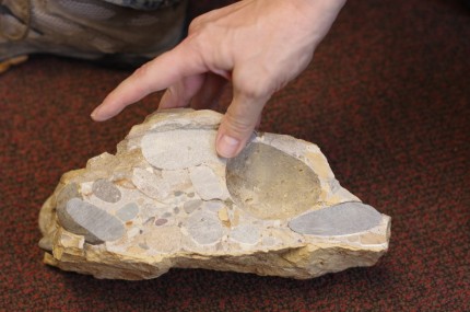
One deposit, similar to what Fought was searching for, was discovered beneath the Grand Mesa in 2008 by former CMU student Dustin Czapla and proved instrumental in charting the history of both the Rocky Mountains and the Colorado River. The sediments Czapla discovered were consistent with rocks known to have existed east of the site in the Rocky Mountains 11 million years ago. This means, according to Aslan, that the Colorado River must have flowed west through the Rocky Mountains and past that site 11 million years ago.
Aslan’s research also involves new theories on how river valleys are formed. Conventional wisdom says that river valleys are formed by water erosion, cutting rock like a knife through cake. Aslan believes that the process also happens in the opposite direction — that the ground (or “cake”) rises up through the eroding river (the “knife”).
Aslan brought up a massive seismology project called the EarthScope US Array that started in 2009. The survey has canvassed much of the United States, measuring differences in the density of rock found in the Earth’s mantle. Aslan believes the survey’s findings suggest that hotter and more buoyant material may be driving areas of land above it upward, directly affecting surface-level topography.
For Aslan, the idea that highly pressurized, super-hot rock 150 km beneath his feet dictates the landscape around him is fascinating.
“It’s fun to learn how your backyard matters,” he said.
crclark2@mavs.coloradomesa.edu

(Dr. Andres Aslan points to sedimentary rocks found in the Colorado River (top) as a potential blueprint for the formation of the Rocky Mountains.)
Categorised in: Features
This post was written by critedev

